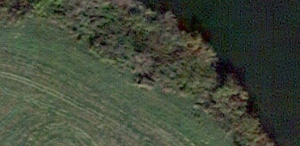
Have you ever looked at your home or some other familiar structure on Google maps from the satellite view? Have you ever used it to check out how concealed something is? The picture below is a container, similar to a shipping container, which I own and is chuck full of goodies. At the time it was painted camouflage and had a green tarp over top of it protecting it from the weather. You can see that it is tucked into the river growth near farm fields and from observation on foot, quite nicely concealed from view. This quick aerial view however, let me know something crucial; I need to cover that bad boy up better from the eyes in the sky. This might seem a little too much like Enemy of the State for some, but I enjoy being sneaky sneaky. Since then I’ve added several layers of old cammo netting and I’ll share a photo as soon as the Google satellite makes its next pass, and we’ll see how well I’ve done in breaking up the shape and color. Try this if you have something tucked away and want to check out how well it holds up against satellites and drones. It’ll feel a little bit like sticking it to the man.
Jon
Image pulled 8SEP14 w/ visible container.
Sadly, google image updated the area; but the family member who owns the land thought it would make sense to kick in the camo netting and mow the are around the container. Prior to the clean up of the area the river growth had moved around the container and it was really starting to blend in both from the ground and from the air. So while the cammo netting corrects the color sceme beautifully; the shape is still aparent and the new growth grass stands out in contrast. I’ll fix it, but probably won’t have an image for you.
Image pulled 8JAN15 w/ visible container.


Leave a Reply